

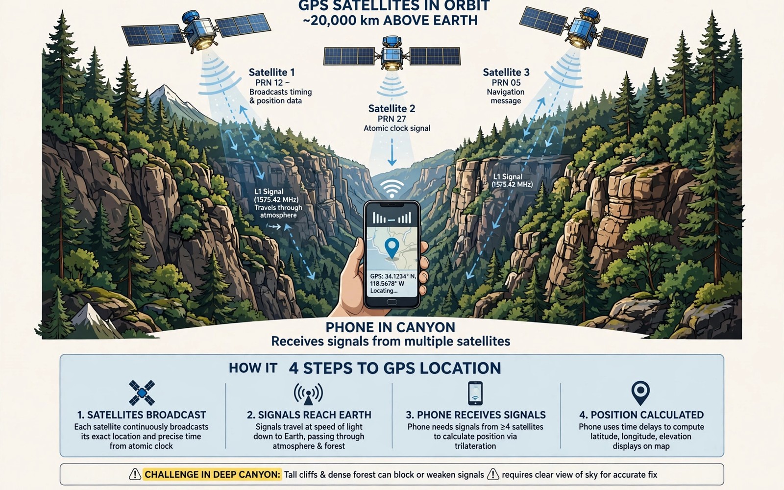
GPS chipsets in canyons and forests face a hard physics problem. Satellite signals are weak by the time they reach the ground. Cliffs block them. Tree canopies absorb them. Reflected signals confuse position maths. Modern chipsets fight these problems with multiple satellite systems and multiple frequencies. This guide explains how that fight works and how to navigate accurately anyway.
A GPS receiver needs signals from at least four satellites to fix a position. Each signal carries timing data. The receiver measures tiny time delays to compute distance to each satellite. Canyon walls block satellites low on the horizon. Only satellites high overhead remain visible. The cell signal in remote wilderness areas fades for similar blocking reasons. GPS needs no mobile signal but it needs open sky. Fewer visible satellites means weaker geometry and larger errors.
GPS accuracy also depends on the time of day and satellite geometry. Satellites move constantly across the sky. Geometry improves when satellites spread widely. Geometry worsens when satellites cluster in one part of the sky. A canyon that blocks half the sky leaves poor geometry at any time. A forest clearing may give good geometry at noon and poor geometry at dusk. Planning fixes for good geometry windows helps critical navigation.
Satellite systems beyond GPS alone
Modern phones use GPS plus other satellite systems together. GLONASS and Galileo and BeiDou add many more satellites to the sky. A phone that sees 30 satellites can lose half to canyon walls and still fix a position. A phone that sees only GPS satellites may lose its fix entirely in the same canyon. Multi system support is essential for canyon and forest use.
Check your phone satellite support in settings or in a satellite test app. Look for support across at least three systems. More systems mean more chances of a fix under cover. A phone with only GPS support is a poor choice for deep terrain. Choose multi system support before you worry about other navigation features.
Multi band signals and accuracy gains
Older GPS used one frequency band known as L1. Newer chipsets add L5 and other bands. Multi band receivers compare signals across bands to correct atmospheric errors. They also reject reflected signals better. Reflected signals travel longer paths and arrive late. That lateness shifts position by metres. Multi band comparison spots the delay and reduces the error.
In cities multi band GPS can reach accuracy under one metre. In canyons accuracy may still reach several metres. That is a large gain over older single band errors of 20 metres or more. For trail navigation a few metres of error is usually safe. For precise survey work it is not enough. Match accuracy expectations to your task. Trail safety needs metres. Property work needs centimetres and dedicated gear.
adb shell dumpsys location 2>/dev/null | grep -i -m 5 'gps\|gnss'
adb shell settings get secure location_mode 2>/dev/null || echo location-mode-check-done
adb shell pm list packages | grep -i -E 'gps|gnss' || echo gnss-package-check-done
Attribution: the snippet above is an original example prepared for this article. It follows a standard public pattern for Android device checks and it does not copy code from any vendor site.
Multipath errors from cliffs and wet trees
Multipath happens when a signal reflects off a cliff or a wet tree before reaching the phone. The reflected path is longer than the direct path. The receiver may use the reflected timing and place you metres away from truth. Canyon walls create strong reflections. Wet leaves scatter signals in many directions. Both effects worsen after rain.
Chipsets reduce multipath by tracking signal shape and strength. Direct signals are usually stronger and cleaner. Reflected signals are weaker and distorted. Smart receivers favour clean signals. They also average many fixes over time to smooth jumps. A position that jumps across a canyon map often signals multipath. Wait and average before trusting a jumpy fix.
Antennas and phone placement for GPS
GPS antennas need a clear view of the sky. A phone deep in a pocket receives weaker signals. A phone on a chest mount or a pack top receives stronger signals. Metal cases block GPS signals like they block mobile signals. Use a plastic or rubber case for canyon trips. Hold the phone flat with the screen up for best antenna orientation during a fix.
Body blocking matters under trees. Your head and shoulders can shade the antenna. Hold the phone away from your body at a trail junction. Wait 30 seconds for the fix to settle. A rushed reading under cover is often wrong by many metres. Patience at junctions prevents wrong turns that cost hours.
Offline maps track logs and waypoint habits
Offline maps turn a rough GPS fix into useful navigation. Download the route area before departure. Save waypoints at junctions and water sources and camps. A waypoint records a position when signal is good. You can navigate back to a good waypoint even when later fixes weaken.
Track logs record your path for return navigation. A log lets you backtrack along your own route. It works even when map detail is poor. Review the log at camp each evening. Note any sections where the track jumped or vanished. Those sections need extra care on the return leg. Good logging habits beat perfect GPS hardware on hard terrain.
When GPS fails and what to do next
GPS can fail in deep slots and under dense wet canopy. A phone may show no fix for many minutes. Do not panic and do not trust a stale position. A stale position looks precise while it is actually old. Check the fix age in your navigation app. An old fix can mislead you badly.
Fall back to map and compass skills when GPS fails. Use terrain features like ridges and streams to confirm position. Move to higher open ground for a fresh fix. A short climb to a ridge often restores satellites. Carry a paper map as backup on every canyon trip. Technology helps navigation but it must never replace basic skills.
Satellite geometry time of day and fix quality
Dilution of precision describes how satellite geometry affects accuracy. Low dilution means satellites spread well and accuracy improves. High dilution means satellites cluster and accuracy worsens. Navigation apps may show dilution values in advanced views. A high dilution warning means you should wait for better geometry or move to open ground.
Morning and evening satellite patterns differ from midday patterns. A route scouted at noon may behave differently at dawn. Critical waypoints deserve fixes at the time you will actually use them. A dawn start needs dawn geometry checks. A noon traverse needs noon checks. Time matched scouting gives honest accuracy expectations.
Assisted GPS speeds first fixes by downloading satellite data over networks. Assisted data helps in open areas with signal. It helps less in deep canyons without networks. A phone without recent assisted data takes longer for a first fix. Download assisted data before departure while signal lasts. Fresh assisted data shortens cold start times on the trail.
Dual frequency phones also improve fix quality under tree cover. A second frequency helps correct ionosphere delays. Ionosphere delays shift signals by metres on single frequency phones. Dual frequency correction matters most for precise work. Trail navigation gains a few metres of accuracy. Survey work gains far more from the same correction.
Fix averaging over a minute improves waypoint accuracy. Stand still at a waypoint and let the phone average many fixes. An averaged waypoint beats a single instant fix under cover. Mark waypoints with averaging when accuracy matters. A rushed single fix under trees can misplace a water source by many metres.
Using barometric sensors alongside GPS altitude
Many rugged phones include a barometric pressure sensor that estimates altitude. Barometric altitude complements GPS altitude in canyons. GPS altitude errors grow larger than horizontal errors under poor geometry. A barometer gives smoother altitude readings during a climb. Calibrate the barometer at a known altitude at the trailhead. Recalibrate when weather fronts change pressure significantly. A calibrated barometer tracks elevation gain more smoothly than GPS alone.
Weather pressure changes can shift barometric altitude by tens of metres over a day. A falling pressure front mimics a climb. A rising front mimics a descent. Compare barometric altitude against map contours at known points. Correct the calibration when the two disagree. Combined GPS and barometer data with map checks gives the most trustworthy elevation picture. No single sensor should decide altitude alone in canyons.
Common mistakes
The biggest mistake is trusting a single jumpy fix at a junction. Multipath can shift a fix by many metres in canyons. Another mistake is keeping the phone deep in a pocket during navigation. Pocket placement weakens satellite reception sharply.
A third mistake is relying on live maps without offline copies. Live maps need data that canyons often lack. Download offline maps before departure. A fourth mistake is ignoring fix age. A stale fix looks exact while it is dangerously old. Check fix time before every critical turn.
A fourth mistake is navigating by a phone compass without calibration. A phone compass drifts near metal and magnets. Calibrate the compass by waving the phone in a figure eight pattern. Recalibrate after exposure to vehicle dashboards and magnetic mounts.
Frequently asked questions
Why does GPS accuracy drop in canyons?
Cliffs block low satellites and leave poor geometry. Reflected signals add multipath errors. Fewer clean signals mean larger position uncertainty. Multi band and multi system chipsets reduce but do not remove these errors.
Do dense forests block GPS completely?
Rarely completely. Leaves absorb and scatter signals but some signals still pass. Accuracy drops and fixes take longer. Openings and ridge tops restore stronger signals quickly.
Is multi band GPS worth paying extra for?
Yes for canyon and forest navigation. Multi band correction cuts errors from tens of metres to a few metres. That gain can prevent wrong turns on faint trails.
Conclusion
GPS chipsets in canyons and forests use many satellites and many bands to fight blocking and reflections. Multi system support and multi band correction give the largest gains. Good placement and offline maps and waypoint habits turn rough fixes into safe navigation. The vehicle mounts that hold heavy phones adds useful context for this choice. The rugged fleets for logistics teams adds useful context for this choice.
Your concrete next step is to check your phone satellite and band support today. Download offline maps for your next canyon route. Then test a fix under trees near home and note the accuracy before you trust it on a trail.
Record fix accuracy at each waypoint on your next trip. Note the accuracy value beside the waypoint name. That record shows which areas need extra care on return trips. Accuracy notes turn a simple track into a trusted navigation resource.